Geo Imaging
Advertisement
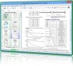
SIMAGIS - Smart Imaging Spreadsheet v.2.0
SIMAGIS is a unique, table-based visual constructor for image processing and editing. It is designed to automate multi-step image processing operations. SIMAGIS greatly simplifies repeatable imaging operations. It automatically saves processing
Advertisement
ERez Imaging Server v.3 2
With the eRez Imaging Server you can share, organize, and create dynamic images for any use--from a browser - anywhere - anytime. Enable users on the Internet to zoom in and examine image details.

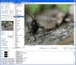
GdPicture Light Imaging SDK - Site License v.2. 8. 2001
GdPicture Light Imaging SDK - Site License is an imaging ActiveX component to create, edit, and compose bitmap images. It can read, convert, print and write images in a large variety of formats. GdPicture Light OCX can be used from any 32 or 64 bit
GdPicture Pro Imaging SDK - Site License v.3. 8. 2001
GdPicture Pro Imaging SDK - Site License is an image activex control to view, create, acquire, edit, print, and compose image bitmap. It can read and write images in a large variety of formats like tiff, tif, jpeg, jpg, png, pdf, ico, wmf, gif, exif,
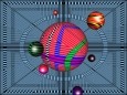
Geo Gizmo 3D Screensaver v.1.0
Welcome to the nanoworld of the Pixel Paradox universe of 2099 AD. Geo Gizmo is a pollution-free nanodevice that acts as a perpetual-motion machine to generate electricity from artificial gravitons in motion above a quantum energy plate,

Aspose.Imaging for Java v.1.7.0.0
Aspose.Imaging for Java is an image processing & manipulation component that allows developers to create, edit, draw or convert images in their Java applications. It allows developers to convert images to BMP, JPEG, TIFF, GIF, PNG & PSD formats.
VintaSoft Imaging .NET SDK v.8.5.0.1
VintaSoft Imaging .NET SDK - an impressive imaging library for .NET, WPF, WEB. WinForms, WPF, WebForms controls for image viewing. 90+ image processing functions. Annotation, JBIG2, JPEG2000, PDF, DocCleanup, OCR, DICOM, OMR/Forms Plug-ins available.
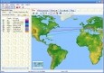
GEO Spider
Now you can trace your network activity on world map. GEO Spider helps you to trace, identify and monitor your network activity on world map. You can trace any website or IP address. Whois reports give to you more info about site, host, domain, ip
Geo Data International Streets
For many countries street coordinates are present with coverage degrees of 100 percent. The geo data offered here are in high-precision quality and are present in several coordinate and reference systems (Geographic, UTM / WGS84, ETRS89). Street
Geo Data International Houses
For many countries house coordinates are present with coverage degrees of 100 percent. The geo data offered here are in high-precision quality and are present in several coordinate and reference systems (Geographic, UTM / WGS84, ETRS89). House Coordinates
Geo Data German Houses
For the area of the Federal Republic of Germany more than 19 million House Coordinates with a coverage of 100% are available. The geo data offered here are in high-precision quality and are present in several coordinate and reference systems.